SlideShare a Scribd company logo
1 of 13
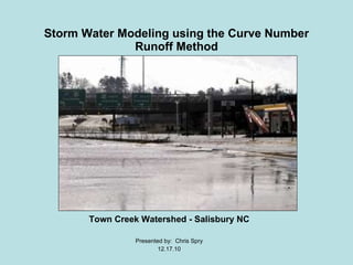
Storm Water Modeling using the Curve Number Runoff Method Town Creek Watershed - Salisbury NC Presented by:  Chris Spry 12.17.10
Context of Problem ,[object Object],[object Object],[object Object],[object Object]
 
Project Objectives ,[object Object],[object Object],[object Object],[object Object]
Methods (Data Collection) ,[object Object],[object Object],[object Object],[object Object],The following  data was required  to complete the project:
 
1978 Aerial vs. 2009 Satellite Imagery Zoomed
Methods (Incorporate data into GIS) ,[object Object],[object Object],[object Object],[object Object],[object Object],[object Object]
Methods: (CRN) Equation ,[object Object],[object Object],[object Object],[object Object],[object Object],[object Object],[object Object],[object Object],[object Object],[object Object],[object Object],[object Object],[object Object]
Results Land Use Statistics for the year (1978) Forest =  53% Open Space =  40% Urban = 7% Flow Accumulation  at Innes St. point from a 4 inch rainfall: 78,592 Land Use Statistics for the year (2009) Forest = 50 % Open Space = 35% Urban = 15% Flow Accumulation  at Innes St. point from a 4 inch rainfall:  92,131 Land Use Change between 1978 and 2009 Forest = -3%  Open Space = - 5% Urban = +8%
Project Significance and Encountered Issues ,[object Object],[object Object],[object Object],[object Object]
 
Thanks for your attention! Questions?

More Related Content

What's hot

TGS Arcis- 2014 Marketing Survey Threehills 3D
TGS Arcis- 2014 Marketing Survey Threehills 3DTGS Arcis- 2014 Marketing Survey Threehills 3D
TGS Arcis- 2014 Marketing Survey Threehills 3DTGS
 
The performance of portable mid-infrared spectroscopy for the prediction of s...
The performance of portable mid-infrared spectroscopy for the prediction of s...The performance of portable mid-infrared spectroscopy for the prediction of s...
The performance of portable mid-infrared spectroscopy for the prediction of s...ExternalEvents
 
AP Calculus AB March 12, 2009
AP Calculus AB March 12, 2009AP Calculus AB March 12, 2009
AP Calculus AB March 12, 2009Darren Kuropatwa
 
Land use classification using taxi gps traces
Land use classification using taxi gps tracesLand use classification using taxi gps traces
Land use classification using taxi gps tracesecwayerode
 
S-Plus: The Data Reduction Process
S-Plus: The Data Reduction ProcessS-Plus: The Data Reduction Process
S-Plus: The Data Reduction ProcessEduardo S. Pereira
 
Bouvet_IGARSS2011.ppt
Bouvet_IGARSS2011.pptBouvet_IGARSS2011.ppt
Bouvet_IGARSS2011.pptgrssieee
 
OESF Logging Road Sedimentation GIS
OESF Logging Road Sedimentation GISOESF Logging Road Sedimentation GIS
OESF Logging Road Sedimentation GISfireflytza
 
Surface Water modelling using Remote Sensing
Surface Water modelling using Remote SensingSurface Water modelling using Remote Sensing
Surface Water modelling using Remote SensingArk Arjun
 
Land use classification using taxi gps traces
Land use classification using taxi gps tracesLand use classification using taxi gps traces
Land use classification using taxi gps tracesEcwaytech
 
GENERATING FINE RESOLUTION LEAF AREA INDEX MAPS FOR BOREAL FORESTS OF FINLAND...
GENERATING FINE RESOLUTION LEAF AREA INDEX MAPS FOR BOREAL FORESTS OF FINLAND...GENERATING FINE RESOLUTION LEAF AREA INDEX MAPS FOR BOREAL FORESTS OF FINLAND...
GENERATING FINE RESOLUTION LEAF AREA INDEX MAPS FOR BOREAL FORESTS OF FINLAND...grssieee
 
A city to national-scale inverse modeling system to assess the potential of s...
A city to national-scale inverse modeling system to assess the potential of s...A city to national-scale inverse modeling system to assess the potential of s...
A city to national-scale inverse modeling system to assess the potential of s...Integrated Carbon Observation System (ICOS)
 
frison.ppt
frison.pptfrison.ppt
frison.pptgrssieee
 
EcoTas13 BradEvans e-MAST
EcoTas13 BradEvans e-MASTEcoTas13 BradEvans e-MAST
EcoTas13 BradEvans e-MASTTERN Australia
 
SURF_Poster_REU2016Team3
SURF_Poster_REU2016Team3SURF_Poster_REU2016Team3
SURF_Poster_REU2016Team3Pablo Valle
 
Nigtrogen Pollution Change Due to Land Use Changes in the Plano/Allen area.
Nigtrogen Pollution Change Due to Land Use Changes in the Plano/Allen area.Nigtrogen Pollution Change Due to Land Use Changes in the Plano/Allen area.
Nigtrogen Pollution Change Due to Land Use Changes in the Plano/Allen area.stoughne
 

What's hot (19)

TGS Arcis- 2014 Marketing Survey Threehills 3D
TGS Arcis- 2014 Marketing Survey Threehills 3DTGS Arcis- 2014 Marketing Survey Threehills 3D
TGS Arcis- 2014 Marketing Survey Threehills 3D
 
The performance of portable mid-infrared spectroscopy for the prediction of s...
The performance of portable mid-infrared spectroscopy for the prediction of s...The performance of portable mid-infrared spectroscopy for the prediction of s...
The performance of portable mid-infrared spectroscopy for the prediction of s...
 
AP Calculus AB March 12, 2009
AP Calculus AB March 12, 2009AP Calculus AB March 12, 2009
AP Calculus AB March 12, 2009
 
Land use classification using taxi gps traces
Land use classification using taxi gps tracesLand use classification using taxi gps traces
Land use classification using taxi gps traces
 
S-Plus: The Data Reduction Process
S-Plus: The Data Reduction ProcessS-Plus: The Data Reduction Process
S-Plus: The Data Reduction Process
 
Iwmo18 ueslei
Iwmo18 uesleiIwmo18 ueslei
Iwmo18 ueslei
 
Bouvet_IGARSS2011.ppt
Bouvet_IGARSS2011.pptBouvet_IGARSS2011.ppt
Bouvet_IGARSS2011.ppt
 
OESF Logging Road Sedimentation GIS
OESF Logging Road Sedimentation GISOESF Logging Road Sedimentation GIS
OESF Logging Road Sedimentation GIS
 
Surface Water modelling using Remote Sensing
Surface Water modelling using Remote SensingSurface Water modelling using Remote Sensing
Surface Water modelling using Remote Sensing
 
Land use classification using taxi gps traces
Land use classification using taxi gps tracesLand use classification using taxi gps traces
Land use classification using taxi gps traces
 
NGS Report
NGS ReportNGS Report
NGS Report
 
GENERATING FINE RESOLUTION LEAF AREA INDEX MAPS FOR BOREAL FORESTS OF FINLAND...
GENERATING FINE RESOLUTION LEAF AREA INDEX MAPS FOR BOREAL FORESTS OF FINLAND...GENERATING FINE RESOLUTION LEAF AREA INDEX MAPS FOR BOREAL FORESTS OF FINLAND...
GENERATING FINE RESOLUTION LEAF AREA INDEX MAPS FOR BOREAL FORESTS OF FINLAND...
 
A city to national-scale inverse modeling system to assess the potential of s...
A city to national-scale inverse modeling system to assess the potential of s...A city to national-scale inverse modeling system to assess the potential of s...
A city to national-scale inverse modeling system to assess the potential of s...
 
frison.ppt
frison.pptfrison.ppt
frison.ppt
 
EcoTas13 BradEvans e-MAST
EcoTas13 BradEvans e-MASTEcoTas13 BradEvans e-MAST
EcoTas13 BradEvans e-MAST
 
SURF_poster
SURF_posterSURF_poster
SURF_poster
 
SURF_Poster_REU2016Team3
SURF_Poster_REU2016Team3SURF_Poster_REU2016Team3
SURF_Poster_REU2016Team3
 
Nigtrogen Pollution Change Due to Land Use Changes in the Plano/Allen area.
Nigtrogen Pollution Change Due to Land Use Changes in the Plano/Allen area.Nigtrogen Pollution Change Due to Land Use Changes in the Plano/Allen area.
Nigtrogen Pollution Change Due to Land Use Changes in the Plano/Allen area.
 
Presentation
PresentationPresentation
Presentation
 

Similar to Chris Spry

Use of Satellite Data for Feasibility Study And Preliminary Design Project Re...
Use of Satellite Data for Feasibility Study And Preliminary Design Project Re...Use of Satellite Data for Feasibility Study And Preliminary Design Project Re...
Use of Satellite Data for Feasibility Study And Preliminary Design Project Re...IJERDJOURNAL
 
Flooding areas of Ofanto river using advanced topographic and hydraulic appro...
Flooding areas of Ofanto river using advanced topographic and hydraulic appro...Flooding areas of Ofanto river using advanced topographic and hydraulic appro...
Flooding areas of Ofanto river using advanced topographic and hydraulic appro...Lia Romano
 
Modeling the Effects of Land Use Change on Flooding
Modeling the Effects of Land Use Change on FloodingModeling the Effects of Land Use Change on Flooding
Modeling the Effects of Land Use Change on FloodingAdam Nayak
 
IRJET- Estimation of Surface Runoff using Curve Number Method- A Geospatial A...
IRJET- Estimation of Surface Runoff using Curve Number Method- A Geospatial A...IRJET- Estimation of Surface Runoff using Curve Number Method- A Geospatial A...
IRJET- Estimation of Surface Runoff using Curve Number Method- A Geospatial A...IRJET Journal
 
Watershed Anylsis for Sevenmile Creek
Watershed Anylsis for Sevenmile CreekWatershed Anylsis for Sevenmile Creek
Watershed Anylsis for Sevenmile CreekAaron King
 
Streamflow simulation using radar-based precipitation applied to the Illinois...
Streamflow simulation using radar-based precipitation applied to the Illinois...Streamflow simulation using radar-based precipitation applied to the Illinois...
Streamflow simulation using radar-based precipitation applied to the Illinois...Alireza Safari
 
Hydrological Risk Assessment at Praia, Cape Verde
Hydrological Risk Assessment at Praia, Cape VerdeHydrological Risk Assessment at Praia, Cape Verde
Hydrological Risk Assessment at Praia, Cape VerdeIJEAB
 
Birr - Identifying Critical Portions of the Landscape
Birr - Identifying Critical Portions of the LandscapeBirr - Identifying Critical Portions of the Landscape
Birr - Identifying Critical Portions of the LandscapeJose A. Hernandez
 
Rainfall Runoff Modelling on the Lower Tapi Basin using HEC-HMS
Rainfall Runoff Modelling on the Lower Tapi Basin using HEC-HMSRainfall Runoff Modelling on the Lower Tapi Basin using HEC-HMS
Rainfall Runoff Modelling on the Lower Tapi Basin using HEC-HMSAnkit Balyan MBA, B.Tech.
 
A GIS-Based Framework to Identify Opportunities to Use Surface Water to Offse...
A GIS-Based Framework to Identify Opportunities to Use Surface Water to Offse...A GIS-Based Framework to Identify Opportunities to Use Surface Water to Offse...
A GIS-Based Framework to Identify Opportunities to Use Surface Water to Offse...ASADULISLAMSORIF
 
IRJET- Estimation of Hydrological and Hydraulics Parameters for Bridge De...
IRJET-  	  Estimation of Hydrological and Hydraulics Parameters for Bridge De...IRJET-  	  Estimation of Hydrological and Hydraulics Parameters for Bridge De...
IRJET- Estimation of Hydrological and Hydraulics Parameters for Bridge De...IRJET Journal
 
Morphometric Analysis to Identify Erosion Prone Areas on the Upper Blue Nile ...
Morphometric Analysis to Identify Erosion Prone Areas on the Upper Blue Nile ...Morphometric Analysis to Identify Erosion Prone Areas on the Upper Blue Nile ...
Morphometric Analysis to Identify Erosion Prone Areas on the Upper Blue Nile ...IRJET Journal
 

Similar to Chris Spry (20)

Use of Satellite Data for Feasibility Study And Preliminary Design Project Re...
Use of Satellite Data for Feasibility Study And Preliminary Design Project Re...Use of Satellite Data for Feasibility Study And Preliminary Design Project Re...
Use of Satellite Data for Feasibility Study And Preliminary Design Project Re...
 
Flooding areas of Ofanto river using advanced topographic and hydraulic appro...
Flooding areas of Ofanto river using advanced topographic and hydraulic appro...Flooding areas of Ofanto river using advanced topographic and hydraulic appro...
Flooding areas of Ofanto river using advanced topographic and hydraulic appro...
 
Modeling the Effects of Land Use Change on Flooding
Modeling the Effects of Land Use Change on FloodingModeling the Effects of Land Use Change on Flooding
Modeling the Effects of Land Use Change on Flooding
 
IRJET- Estimation of Surface Runoff using Curve Number Method- A Geospatial A...
IRJET- Estimation of Surface Runoff using Curve Number Method- A Geospatial A...IRJET- Estimation of Surface Runoff using Curve Number Method- A Geospatial A...
IRJET- Estimation of Surface Runoff using Curve Number Method- A Geospatial A...
 
Hampton-Rds-MATS-Poster-2
Hampton-Rds-MATS-Poster-2Hampton-Rds-MATS-Poster-2
Hampton-Rds-MATS-Poster-2
 
Watershed Anylsis for Sevenmile Creek
Watershed Anylsis for Sevenmile CreekWatershed Anylsis for Sevenmile Creek
Watershed Anylsis for Sevenmile Creek
 
Streamflow simulation using radar-based precipitation applied to the Illinois...
Streamflow simulation using radar-based precipitation applied to the Illinois...Streamflow simulation using radar-based precipitation applied to the Illinois...
Streamflow simulation using radar-based precipitation applied to the Illinois...
 
Ijirt148701 paper
Ijirt148701 paperIjirt148701 paper
Ijirt148701 paper
 
Hydrological Risk Assessment at Praia, Cape Verde
Hydrological Risk Assessment at Praia, Cape VerdeHydrological Risk Assessment at Praia, Cape Verde
Hydrological Risk Assessment at Praia, Cape Verde
 
Birr - Identifying Critical Portions of the Landscape
Birr - Identifying Critical Portions of the LandscapeBirr - Identifying Critical Portions of the Landscape
Birr - Identifying Critical Portions of the Landscape
 
Ijciet 08 04_235
Ijciet 08 04_235Ijciet 08 04_235
Ijciet 08 04_235
 
Rainfall Runoff Modelling on the Lower Tapi Basin using HEC-HMS
Rainfall Runoff Modelling on the Lower Tapi Basin using HEC-HMSRainfall Runoff Modelling on the Lower Tapi Basin using HEC-HMS
Rainfall Runoff Modelling on the Lower Tapi Basin using HEC-HMS
 
06Surface_Runoff.pdf
06Surface_Runoff.pdf06Surface_Runoff.pdf
06Surface_Runoff.pdf
 
A GIS-Based Framework to Identify Opportunities to Use Surface Water to Offse...
A GIS-Based Framework to Identify Opportunities to Use Surface Water to Offse...A GIS-Based Framework to Identify Opportunities to Use Surface Water to Offse...
A GIS-Based Framework to Identify Opportunities to Use Surface Water to Offse...
 
IRJET- Estimation of Hydrological and Hydraulics Parameters for Bridge De...
IRJET-  	  Estimation of Hydrological and Hydraulics Parameters for Bridge De...IRJET-  	  Estimation of Hydrological and Hydraulics Parameters for Bridge De...
IRJET- Estimation of Hydrological and Hydraulics Parameters for Bridge De...
 
FLOODPLAIN HAZARD MAPPING AND ASSESSMENT OF RIVER KABUL USING HEC-RAS 2D MODEL
FLOODPLAIN HAZARD MAPPING AND ASSESSMENT OF RIVER KABUL USING HEC-RAS 2D MODELFLOODPLAIN HAZARD MAPPING AND ASSESSMENT OF RIVER KABUL USING HEC-RAS 2D MODEL
FLOODPLAIN HAZARD MAPPING AND ASSESSMENT OF RIVER KABUL USING HEC-RAS 2D MODEL
 
Goiul.ppt
Goiul.pptGoiul.ppt
Goiul.ppt
 
Work_Sample_Paper
Work_Sample_PaperWork_Sample_Paper
Work_Sample_Paper
 
2 ijsrms-02753
2 ijsrms-027532 ijsrms-02753
2 ijsrms-02753
 
Morphometric Analysis to Identify Erosion Prone Areas on the Upper Blue Nile ...
Morphometric Analysis to Identify Erosion Prone Areas on the Upper Blue Nile ...Morphometric Analysis to Identify Erosion Prone Areas on the Upper Blue Nile ...
Morphometric Analysis to Identify Erosion Prone Areas on the Upper Blue Nile ...
 

More from Wuzzy13

Chris Spry
Chris SpryChris Spry
Chris SpryWuzzy13
 
Group Final Project (Revised-2)
Group Final Project (Revised-2)Group Final Project (Revised-2)
Group Final Project (Revised-2)Wuzzy13
 
Group Final Project (Revised)
Group Final Project (Revised)Group Final Project (Revised)
Group Final Project (Revised)Wuzzy13
 
Group Final project
Group Final projectGroup Final project
Group Final projectWuzzy13
 
Final project2
Final project2Final project2
Final project2Wuzzy13
 
El salvador
El salvadorEl salvador
El salvadorWuzzy13
 
Chris Spry Ozone Project
Chris Spry Ozone ProjectChris Spry Ozone Project
Chris Spry Ozone ProjectWuzzy13
 
Chris Spry Final Rs Project
Chris Spry Final Rs ProjectChris Spry Final Rs Project
Chris Spry Final Rs ProjectWuzzy13
 
Chris Spry Ikonos
Chris Spry IkonosChris Spry Ikonos
Chris Spry IkonosWuzzy13
 

More from Wuzzy13 (9)

Chris Spry
Chris SpryChris Spry
Chris Spry
 
Group Final Project (Revised-2)
Group Final Project (Revised-2)Group Final Project (Revised-2)
Group Final Project (Revised-2)
 
Group Final Project (Revised)
Group Final Project (Revised)Group Final Project (Revised)
Group Final Project (Revised)
 
Group Final project
Group Final projectGroup Final project
Group Final project
 
Final project2
Final project2Final project2
Final project2
 
El salvador
El salvadorEl salvador
El salvador
 
Chris Spry Ozone Project
Chris Spry Ozone ProjectChris Spry Ozone Project
Chris Spry Ozone Project
 
Chris Spry Final Rs Project
Chris Spry Final Rs ProjectChris Spry Final Rs Project
Chris Spry Final Rs Project
 
Chris Spry Ikonos
Chris Spry IkonosChris Spry Ikonos
Chris Spry Ikonos
 

Recently uploaded

AI as an Interface for Commercial Buildings
AI as an Interface for Commercial BuildingsAI as an Interface for Commercial Buildings
AI as an Interface for Commercial BuildingsMemoori
 
SQL Database Design For Developers at php[tek] 2024
SQL Database Design For Developers at php[tek] 2024SQL Database Design For Developers at php[tek] 2024
SQL Database Design For Developers at php[tek] 2024Scott Keck-Warren
 
Integration and Automation in Practice: CI/CD in Mule Integration and Automat...
Integration and Automation in Practice: CI/CD in Mule Integration and Automat...Integration and Automation in Practice: CI/CD in Mule Integration and Automat...
Integration and Automation in Practice: CI/CD in Mule Integration and Automat...Patryk Bandurski
 
Are Multi-Cloud and Serverless Good or Bad?
Are Multi-Cloud and Serverless Good or Bad?Are Multi-Cloud and Serverless Good or Bad?
Are Multi-Cloud and Serverless Good or Bad?Mattias Andersson
 
"Federated learning: out of reach no matter how close",Oleksandr Lapshyn
"Federated learning: out of reach no matter how close",Oleksandr Lapshyn"Federated learning: out of reach no matter how close",Oleksandr Lapshyn
"Federated learning: out of reach no matter how close",Oleksandr LapshynFwdays
 
Science&tech:THE INFORMATION AGE STS.pdf
Science&tech:THE INFORMATION AGE STS.pdfScience&tech:THE INFORMATION AGE STS.pdf
Science&tech:THE INFORMATION AGE STS.pdfjimielynbastida
 
Connect Wave/ connectwave Pitch Deck Presentation
Connect Wave/ connectwave Pitch Deck PresentationConnect Wave/ connectwave Pitch Deck Presentation
Connect Wave/ connectwave Pitch Deck PresentationSlibray Presentation
 
Tech-Forward - Achieving Business Readiness For Copilot in Microsoft 365
Tech-Forward - Achieving Business Readiness For Copilot in Microsoft 365Tech-Forward - Achieving Business Readiness For Copilot in Microsoft 365
Tech-Forward - Achieving Business Readiness For Copilot in Microsoft 3652toLead Limited
 
Transcript: New from BookNet Canada for 2024: BNC BiblioShare - Tech Forum 2024
Transcript: New from BookNet Canada for 2024: BNC BiblioShare - Tech Forum 2024Transcript: New from BookNet Canada for 2024: BNC BiblioShare - Tech Forum 2024
Transcript: New from BookNet Canada for 2024: BNC BiblioShare - Tech Forum 2024BookNet Canada
 
Bun (KitWorks Team Study 노별마루 발표 2024.4.22)
Bun (KitWorks Team Study 노별마루 발표 2024.4.22)Bun (KitWorks Team Study 노별마루 발표 2024.4.22)
Bun (KitWorks Team Study 노별마루 발표 2024.4.22)Wonjun Hwang
 
Designing IA for AI - Information Architecture Conference 2024
Designing IA for AI - Information Architecture Conference 2024Designing IA for AI - Information Architecture Conference 2024
Designing IA for AI - Information Architecture Conference 2024Enterprise Knowledge
 
Transcript: #StandardsGoals for 2024: What’s new for BISAC - Tech Forum 2024
Transcript: #StandardsGoals for 2024: What’s new for BISAC - Tech Forum 2024Transcript: #StandardsGoals for 2024: What’s new for BISAC - Tech Forum 2024
Transcript: #StandardsGoals for 2024: What’s new for BISAC - Tech Forum 2024BookNet Canada
 
Unblocking The Main Thread Solving ANRs and Frozen Frames
Unblocking The Main Thread Solving ANRs and Frozen FramesUnblocking The Main Thread Solving ANRs and Frozen Frames
Unblocking The Main Thread Solving ANRs and Frozen FramesSinan KOZAK
 
Understanding the Laravel MVC Architecture
Understanding the Laravel MVC ArchitectureUnderstanding the Laravel MVC Architecture
Understanding the Laravel MVC ArchitecturePixlogix Infotech
 
Artificial intelligence in the post-deep learning era
Artificial intelligence in the post-deep learning eraArtificial intelligence in the post-deep learning era
Artificial intelligence in the post-deep learning eraDeakin University
 
Scanning the Internet for External Cloud Exposures via SSL Certs
Scanning the Internet for External Cloud Exposures via SSL CertsScanning the Internet for External Cloud Exposures via SSL Certs
Scanning the Internet for External Cloud Exposures via SSL CertsRizwan Syed
 
Beyond Boundaries: Leveraging No-Code Solutions for Industry Innovation
Beyond Boundaries: Leveraging No-Code Solutions for Industry InnovationBeyond Boundaries: Leveraging No-Code Solutions for Industry Innovation
Beyond Boundaries: Leveraging No-Code Solutions for Industry InnovationSafe Software
 
Pigging Solutions in Pet Food Manufacturing
Pigging Solutions in Pet Food ManufacturingPigging Solutions in Pet Food Manufacturing
Pigging Solutions in Pet Food ManufacturingPigging Solutions
 

Recently uploaded (20)

AI as an Interface for Commercial Buildings
AI as an Interface for Commercial BuildingsAI as an Interface for Commercial Buildings
AI as an Interface for Commercial Buildings
 
SQL Database Design For Developers at php[tek] 2024
SQL Database Design For Developers at php[tek] 2024SQL Database Design For Developers at php[tek] 2024
SQL Database Design For Developers at php[tek] 2024
 
The transition to renewables in India.pdf
The transition to renewables in India.pdfThe transition to renewables in India.pdf
The transition to renewables in India.pdf
 
Integration and Automation in Practice: CI/CD in Mule Integration and Automat...
Integration and Automation in Practice: CI/CD in Mule Integration and Automat...Integration and Automation in Practice: CI/CD in Mule Integration and Automat...
Integration and Automation in Practice: CI/CD in Mule Integration and Automat...
 
Are Multi-Cloud and Serverless Good or Bad?
Are Multi-Cloud and Serverless Good or Bad?Are Multi-Cloud and Serverless Good or Bad?
Are Multi-Cloud and Serverless Good or Bad?
 
"Federated learning: out of reach no matter how close",Oleksandr Lapshyn
"Federated learning: out of reach no matter how close",Oleksandr Lapshyn"Federated learning: out of reach no matter how close",Oleksandr Lapshyn
"Federated learning: out of reach no matter how close",Oleksandr Lapshyn
 
Science&tech:THE INFORMATION AGE STS.pdf
Science&tech:THE INFORMATION AGE STS.pdfScience&tech:THE INFORMATION AGE STS.pdf
Science&tech:THE INFORMATION AGE STS.pdf
 
Hot Sexy call girls in Panjabi Bagh 🔝 9953056974 🔝 Delhi escort Service
Hot Sexy call girls in Panjabi Bagh 🔝 9953056974 🔝 Delhi escort ServiceHot Sexy call girls in Panjabi Bagh 🔝 9953056974 🔝 Delhi escort Service
Hot Sexy call girls in Panjabi Bagh 🔝 9953056974 🔝 Delhi escort Service
 
Connect Wave/ connectwave Pitch Deck Presentation
Connect Wave/ connectwave Pitch Deck PresentationConnect Wave/ connectwave Pitch Deck Presentation
Connect Wave/ connectwave Pitch Deck Presentation
 
Tech-Forward - Achieving Business Readiness For Copilot in Microsoft 365
Tech-Forward - Achieving Business Readiness For Copilot in Microsoft 365Tech-Forward - Achieving Business Readiness For Copilot in Microsoft 365
Tech-Forward - Achieving Business Readiness For Copilot in Microsoft 365
 
Transcript: New from BookNet Canada for 2024: BNC BiblioShare - Tech Forum 2024
Transcript: New from BookNet Canada for 2024: BNC BiblioShare - Tech Forum 2024Transcript: New from BookNet Canada for 2024: BNC BiblioShare - Tech Forum 2024
Transcript: New from BookNet Canada for 2024: BNC BiblioShare - Tech Forum 2024
 
Bun (KitWorks Team Study 노별마루 발표 2024.4.22)
Bun (KitWorks Team Study 노별마루 발표 2024.4.22)Bun (KitWorks Team Study 노별마루 발표 2024.4.22)
Bun (KitWorks Team Study 노별마루 발표 2024.4.22)
 
Designing IA for AI - Information Architecture Conference 2024
Designing IA for AI - Information Architecture Conference 2024Designing IA for AI - Information Architecture Conference 2024
Designing IA for AI - Information Architecture Conference 2024
 
Transcript: #StandardsGoals for 2024: What’s new for BISAC - Tech Forum 2024
Transcript: #StandardsGoals for 2024: What’s new for BISAC - Tech Forum 2024Transcript: #StandardsGoals for 2024: What’s new for BISAC - Tech Forum 2024
Transcript: #StandardsGoals for 2024: What’s new for BISAC - Tech Forum 2024
 
Unblocking The Main Thread Solving ANRs and Frozen Frames
Unblocking The Main Thread Solving ANRs and Frozen FramesUnblocking The Main Thread Solving ANRs and Frozen Frames
Unblocking The Main Thread Solving ANRs and Frozen Frames
 
Understanding the Laravel MVC Architecture
Understanding the Laravel MVC ArchitectureUnderstanding the Laravel MVC Architecture
Understanding the Laravel MVC Architecture
 
Artificial intelligence in the post-deep learning era
Artificial intelligence in the post-deep learning eraArtificial intelligence in the post-deep learning era
Artificial intelligence in the post-deep learning era
 
Scanning the Internet for External Cloud Exposures via SSL Certs
Scanning the Internet for External Cloud Exposures via SSL CertsScanning the Internet for External Cloud Exposures via SSL Certs
Scanning the Internet for External Cloud Exposures via SSL Certs
 
Beyond Boundaries: Leveraging No-Code Solutions for Industry Innovation
Beyond Boundaries: Leveraging No-Code Solutions for Industry InnovationBeyond Boundaries: Leveraging No-Code Solutions for Industry Innovation
Beyond Boundaries: Leveraging No-Code Solutions for Industry Innovation
 
Pigging Solutions in Pet Food Manufacturing
Pigging Solutions in Pet Food ManufacturingPigging Solutions in Pet Food Manufacturing
Pigging Solutions in Pet Food Manufacturing
 

Chris Spry

  • 1. Storm Water Modeling using the Curve Number Runoff Method Town Creek Watershed - Salisbury NC Presented by: Chris Spry 12.17.10
  • 2.
  • 3.  
  • 4.
  • 5.
  • 6.  
  • 7. 1978 Aerial vs. 2009 Satellite Imagery Zoomed
  • 8.
  • 9.
  • 10. Results Land Use Statistics for the year (1978) Forest = 53% Open Space = 40% Urban = 7% Flow Accumulation at Innes St. point from a 4 inch rainfall: 78,592 Land Use Statistics for the year (2009) Forest = 50 % Open Space = 35% Urban = 15% Flow Accumulation at Innes St. point from a 4 inch rainfall: 92,131 Land Use Change between 1978 and 2009 Forest = -3% Open Space = - 5% Urban = +8%
  • 11.
  • 12.  
  • 13. Thanks for your attention! Questions?